Heading off track? Heading on a trail? In this article, I take a quick look at some of the navigation options (and skills) available to both the casual and serious adventurer (alongside a brief review of the AllTrails GPS app).
The bottom line
- If you’re serious about bushwalking, canyoning or any form of outdoors adventure, you need to know the fundamentals of navigation.
- If you’re doing any adventure of note, you should also take a map and compass with you. They’ll never break or run out of batteries.
- If you’re going into seriously remote country or harsh conditions then a specialist GPS device is definitely a worthwhile consideration.
- The modern breed of mobile GPS apps are the perfect complement for most of us. I can’t recommend downloading one enough. Just don’t rely on it alone to get you out of a sticky situation.
Want more details? Read on!
The basic rules (or knowing how to navigate with a map and compass)

Knowing how to read a map and use a compass is critical. No two ways around it. Case in point: it’s incredibly easy to take a wrong turn, even if you’re on a defined trail. This has happened to me multiple times in Heathcote National Park with its network of intersecting trails and creeks.
The good news is that gaining basic navigation skills is pretty straight forward. Blue-Mountains-based Caro Ryan has a few helpful articles on her blog. For those who are a bit more serious about getting off track, buy a copy of her book How to Navigate or,even better, complete a course.
A map and compass also don’t need batteries, won’t break if you drop them and can be scribbled all over. These days a lot of topographic maps are freely available online. In NSW, the best resource is Six Maps. There’s no excuse not to have a map and compass in your pack if you’re going into unfamiliar terrain.
The GPS device (and its imminent demise for anyone who’s not totally hardcore about adventuring)

A few years ago, I got lost in Budawang National Park with a party of very experienced bushwalkers. It wasn’t until we consulted Bob’s GPS device that we realised what had gone wrong.
As soon as I got home, I purchased one of my own (a Garmin). But I’ve only used it a handful of times and never to my satisfaction. Why? The user interface on my (cheaper) model is terrible, the screen is tiny and the AA batteries seem to always die on me. I also had to purchase digital maps. On top of that, it was heavy and clunky. Since then, it’s been hanging in my gear cupboard, waiting to become e-waste.
Sure, they’re waterproof, which could be a factor in your choice of tool. There is also a niche for specialist GPS devices such as the Garmin InReach, which is linked to a satellite network and allows two-way communication, no matter where you are. But, if like me, you’re not spending a heap of time in the backcountry, you probably won’t need those extra features (and the massive associated cost).
Introducing the new breed of GPS mobile apps

Modern GPS apps have been around for a while. There are a few of them out there, including Maps.me, Avenza and AllTrails. They all share the same basic features:
- use a phone’s in-built GPS to pinpoint your location
- have a decent user interface, including on your desktop browser
- track real-time movements on various types of maps
- don’t require you to carry another device
- get accurate indications of a walk’s length and elevation gain/loss
- feature maps that can be downloaded for offline use
- allow you to “record” your adventure (geospatially at least)
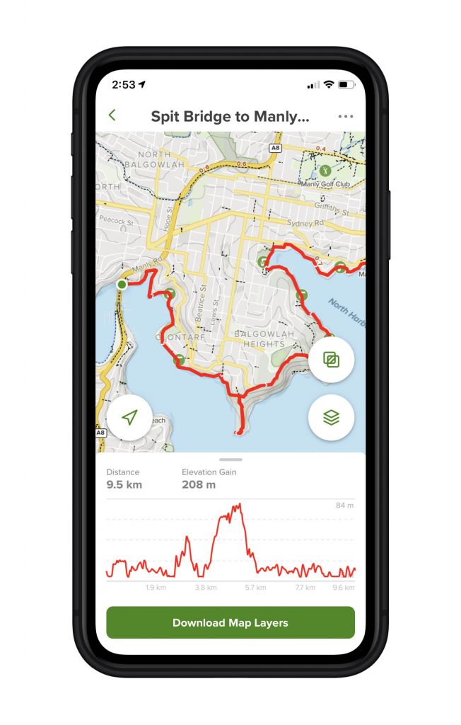
Each app will generally have a free and “pro” version that unlocks additional functionality. I got given a 1-year Pro subscription to AllTrails to review. While I haven’t done a full category scan, I’m totally sold on the concept.
AllTrail’s free version allows you to search for listed (or curated) trails as well as user-generated community content, including user ratings. It also lets you pinpoint your exact location on a trail and, here’s the beauty of it, overlay it onto a topographic map. This map shows not only roads but also service trails and defined walking tracks.
In the Blue Mountains I was able to decipher a network of service trails on the edge of Blackheath, not listed anywhere. The result: a lovely afternoon escape and the discovery of gangang cockatoos in their nesting hollow.
So why go Pro? For a $30/year subscription, you’ll get access to the app’s best feature: downloadable maps. If you’re planning on getting out of mobile range (which is pretty easy to do), this app will serve you well. Case in point: I spent a few days camping in Wollemi National Park and downloaded relevant maps and a couple of walks before I left. This information exceeded any resources provided by National Parks. Not only did I have a detailed topographic map with marked trails but I was also able to see my exact location at any given time. All this despite being totally off the grid.
Pro gets you a few other bells and whistles too: off-route notifications, real-time tracking updates to others and real-time map overlays (notably for weather and pollen). You can also print out maps (so you’ve always got a back-up in case your phone dies).
I haven’t used AllTrails, or indeed any other GPS app, on a serious overnight hike yet. I’m sure they’ll prove their worth.
NOTE: I was provided a one-year subscription to AllTrails pro for review purposes. The views are entirely my own.


No Comments